Drones have changed the way Britain looks at construction sites, transport projects and land development. From a few hundred feet above the ground, a drone can capture detailed images of a site in a fraction of the time required by traditional surveying methods. But aerial visibility is not the same thing as precise measurement.
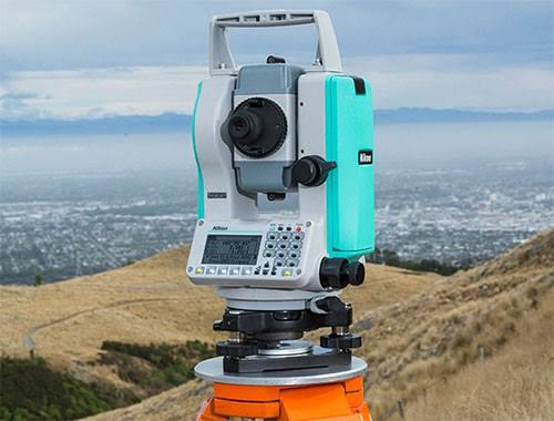
This is where total stations continue to have an important role. While drones can provide an impressive overview, surveyors still need reliable ground-based measurements for setting out, checking positions and validating digital models. A Nikon total station can therefore sit alongside drones, GNSS receivers and modern software rather than being replaced by them.
For survey teams working across the UK, this combined approach is becoming increasingly relevant. With pressure to complete projects efficiently, reduce rework and make better use of digital information, the future of surveying may not be about choosing between old and new technology. It may be about making the technologies work together.
Drones Have Changed the Surveying Conversation
A drone can cover a large area quickly. This makes it particularly useful for construction sites, quarries, road projects, agricultural land and large-scale development.
Instead of sending a surveyor across an entire site simply to understand its current condition, a drone can collect hundreds or thousands of images. Those images can then be processed into orthomosaics, point clouds and three-dimensional models.
For UK construction companies facing demanding schedules, this can save valuable time. A site manager can obtain a visual record of progress without waiting for a conventional site inspection to cover every corner.
However, there is an important limitation. Aerial imagery tells you what a site looks like, but it does not automatically answer every question about precise coordinates, elevations or construction tolerances.
That distinction is why ground-based instruments remain relevant.
Why Total Stations Still Matter
A total station combines several measurement functions into one surveying instrument. It can measure angles and distances and help surveyors determine precise positions on the ground.
Consider a building project. A drone may produce an excellent three-dimensional representation of the site, but the construction team may still need to establish the exact position of a column, wall, foundation or drainage feature.
This is where a total station becomes particularly useful.
Nikon has a long history in optical measurement technology, and Nikon total stations can serve as an example of how established surveying equipment can fit into a modern digital workflow. The instrument does not have to compete with a drone. Instead, it can provide the highly controlled ground measurements needed to check and complement aerial information.
The result is a workflow in which each technology does what it does best.
From the Sky to the Ground
Imagine a large infrastructure project somewhere in the UK. A drone begins by surveying the wider site, collecting imagery that can be converted into a digital surface model.
The survey team can then identify areas that require closer inspection. Instead of measuring every point manually, surveyors can use the aerial data to focus their ground-based work where precision matters most.
A total station can subsequently be used to establish control points, verify critical locations and support setting-out activities.
This creates a useful division of labour. The drone provides speed and coverage, while the total station provides controlled, precise measurements at ground level.
For busy UK projects, this combination can be more practical than treating either technology as a complete replacement for the other.
Battery Reliability Is Part of the Workflow
There is another factor that is easy to overlook: power.
Modern surveying equipment may contain advanced optics, electronic measurement systems, wireless communication functions and digital interfaces. None of these features is particularly useful if the instrument runs out of power halfway through a demanding site operation.
This makes battery management an important part of professional fieldwork. Survey teams often work outdoors for long periods, sometimes in changing weather and away from convenient charging points.
Having suitable Nikon Batteries available can therefore make a difference to daily planning. A spare battery can reduce unnecessary interruptions, particularly when a team is moving between different areas of a large site.
For companies managing several instruments, maintaining an organised stock of Nikon Batteries can also help avoid a surprisingly simple problem: having the equipment ready but not having enough usable power to keep it operating.
British Weather Makes Preparation Essential
Surveying in Britain comes with a familiar challenge: the weather rarely follows the schedule.
A project might begin under clear skies and finish in rain, wind or low temperatures. Conditions can change quickly, particularly on exposed construction sites and rural infrastructure projects.
Surveyors therefore need to think beyond the specifications of individual instruments. Batteries, protective cases, charging equipment and backup equipment all form part of a practical field kit.
This is another reason why Nikon Batteries can be considered within the wider surveying workflow rather than simply as an accessory. Reliable power supports continuity, and continuity matters when a team has limited access to the site or a narrow window for completing measurements.
Good preparation can prevent a small power issue from becoming a much larger scheduling problem.
The Rise of BIM and Digital Construction
Britain’s construction sector is becoming increasingly dependent on digital information. Building Information Modelling, cloud-based project management and three-dimensional site data are changing how teams plan and monitor projects.
The challenge is ensuring that digital models accurately reflect physical reality.
A drone can contribute large quantities of visual and spatial data. GNSS technology can provide positioning information. A total station can deliver precise measurements at selected locations.
Together, these technologies can create a stronger feedback loop between the digital model and the real construction site.
For example, if a contractor needs to verify whether a structural element has been installed in the correct position, ground-based measurement can provide a direct check. If discrepancies are found early, the project team may be able to address them before they lead to costly rework.
This is where surveying technology becomes more than a measurement tool. It becomes part of the information infrastructure of a construction project.
AI Could Make the Data Even More Useful
Artificial intelligence is increasingly being discussed across Britain’s technology and construction sectors. In surveying, one of the most interesting opportunities is not necessarily replacing surveyors, but helping them process large volumes of information more efficiently.
A drone can generate enormous datasets. Automated software can identify patterns, classify objects and compare different site surveys.
But better data processing does not remove the need for reliable data collection.
If the original measurements are inaccurate or poorly controlled, sophisticated software cannot magically turn them into dependable information. Ground-based instruments therefore remain important for establishing and checking the quality of spatial data.
In this environment, a Nikon total station can represent the measurement layer that supports a broader digital ecosystem. The future surveyor may spend less time collecting routine information manually and more time managing, checking and interpreting data from several connected technologies.
Infrastructure Projects Need Multiple Technologies
The UK’s transport and infrastructure landscape provides an obvious example of why this matters.
Railway upgrades, road improvements, utilities, housing developments and urban regeneration projects can cover large and complicated areas. Different parts of the same project may require different surveying techniques.
A drone can quickly capture progress across a construction corridor. GNSS equipment can help establish positioning over open areas. A total station can be used where highly controlled measurements are required, especially around structures or locations where satellite signals may be less dependable.
This multi-technology approach can also improve communication between different teams. Engineers, surveyors, contractors and project managers can work from a shared digital representation of the site while still having access to precise field measurements.
The key is not to ask which technology is the newest. The better question is which combination produces the most useful result.
Battery Planning Becomes More Important as Equipment Gets Smarter
As surveying instruments become more connected, power requirements and operational planning deserve greater attention.
Wireless data transfer, electronic displays and additional onboard functions can all affect how long equipment can operate in the field. Survey teams working on extensive sites may therefore need to plan charging and battery changes alongside their daily measurement schedule.
Keeping several Nikon Batteries properly maintained can be a straightforward way to improve operational resilience. It also allows teams to rotate batteries instead of stopping work whenever one reaches a low charge.
For contractors, this is a small operational detail with potentially significant consequences. A few minutes spent changing a battery is manageable; losing a critical measurement window because equipment cannot operate is much less convenient.
The Surveyor Is Still at the Centre
Despite the rapid development of drones, AI and automated mapping, surveying remains a profession that depends on judgement.
A drone can collect imagery. Software can create a point cloud. A total station can measure an exact location. But someone still needs to decide what should be measured, whether the data makes sense and how the results should influence the project.
This human element is particularly important when working in complex urban environments or on infrastructure projects where tolerances are tight.
Technology can make a surveyor faster and better informed, but it does not eliminate professional responsibility.
What the Future Surveying Workflow Could Look Like
The surveying workflow of the future is unlikely to be entirely aerial or entirely ground-based.
A typical project could begin with drone imagery to understand the wider site. Digital processing could then create a detailed model. GNSS and total stations could establish and verify control points, while targeted measurements could confirm critical construction features.
AI-assisted software could help compare new data with previous surveys and highlight potential differences. Surveyors could then investigate those areas and provide verified information to engineers and contractors.
In such a system, the total station is not an outdated piece of equipment sitting beside futuristic technology. It is one component of an integrated measurement network.
Nikon provides a useful example of this transition. Its surveying equipment demonstrates how established precision measurement principles can remain relevant even as the surrounding workflow becomes increasingly digital.
A Smarter Future Is About Integration
The biggest lesson from the rise of drone surveying is perhaps surprisingly simple: seeing more does not necessarily mean measuring better.
Drones offer speed, scale and a valuable aerial perspective. Total stations offer controlled ground-based measurement and precise positioning. GNSS, cloud platforms, BIM and AI add further layers of capability.
When these technologies are integrated intelligently, UK survey teams can potentially collect information faster while maintaining the level of accuracy required for demanding projects.
And beneath all the discussion about artificial intelligence and autonomous surveying, practical details still matter. Equipment needs to be available, prepared and powered when the survey team needs it. For users of compatible Nikon equipment, keeping dependable Nikon Batteries ready for fieldwork can be just as important as having the latest software.
The future of surveying is therefore unlikely to belong exclusively to drones or robots. It will belong to workflows that combine aerial vision, ground-level precision and human expertise. Drones may show us the whole picture from above, but on Britain’s construction sites, someone still needs to measure what is happening on the ground.